Drone Project Support
SynTerra takes projects to new heights by collecting data from previously inaccessible places.
SynTerra uses drones to collect detailed imagery and real-time data from hard-to-reach and previously inaccessible places. Bolstered by high-resolution cameras and thermal sensors, our advanced aerial capabilities support project goals, enhance work products, improve results, and reduce risk while maintaining or reducing project costs.
With drones, it’s easier and safer to inspect elevated structures such as rooftops and towers, confined spaces such as tanks and tunnels, and large areas such as quarries, landfills, and wastewater systems. SynTerra uses drones to conduct environmental monitoring and to collect data for survey-grade maps and 3D models that support civil engineering projects. And it all can be done in hours on-site instead of days.
SynTerra drone capabilities
Accessibility
- Accessing difficult-to-reach areas (e.g., towers/antenna, stacks, roofs, conveyors, piping racks, riverbanks)
- Accessing confined spaces (e.g., tanks, vessels, utility corridors)
- Covering large acreage or features (e.g., storage yards, mine/borrow pits, wastewater systems, dams and dikes, pipelines)
- Construction site progress monitoring
- High-resolution images and video
- Thermal imaging
- Orthoimagery (e.g., georeferenced aerial photography)
- GIS integration
- Facility overviews to support orientation and training requirements
- Topographic surveys (link to surveying page)
- Civil site design services
Surveying and mapping solutions
- Topographic mapping to support civil engineering projects
- Volumetric surveys/estimates for inventory tracking, agency reporting, and planning (landfill volume and life projection; material quantity estimates for chip, bark, log, coal piles, etc.; pit progress reporting and overburden estimates; and more)
- Thermal mapping for energy efficiency evaluation, wastewater treatment assessment, wildlife studies, habitat identification, etc.
- High-resolution data – when tied into differential GPS (RTK or PPK), accuracy is down to inches and a dense point cloud is collected for use in generating 3D models, topographic maps, etc.
Other benefits
- Small and lightweight equipment
- Easy setup and programming of flights
- High-resolution images, video, and survey data
- Lower risk/improved safety
- Competitive pricing when compared with traditional approaches
- Reduced site time
- Self- or hand-launched equipment
Project example: Underground abandoned coal mine
Client challenge
An ongoing fire in an abandoned underground coal mine had plagued a community in eastern Kentucky for years. Residents of a nearby city were subjected to potentially toxic emissions continually coming out of the ground. Such releases can lead to respiratory problems. The emissions also can potentially affect surface water and groundwater and can even ignite forest fires. Because abandoned mines often have collapsed, and with the situation further complicated by insufficient mapping, identifying underground hot spots can be difficult.
SynTerra solution
SynTerra — with vast expertise in mining engineering, drone operation, and mapping solutions — set out to collect previously elusive data and identify the hot spots.
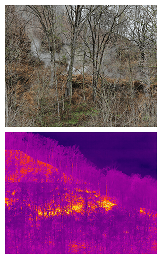
Using unmanned aerial system-based thermal imaging, SynTerra pinpointed the location of those hot spots, essential to conducting remediation efforts with the goal of extinguishing the fire. A combination of the thermal imagery overlain with LiDAR mapping of the area of interest provided a valuable working exhibit of the pertinent conditions. That exhibit was essential in forming a remedial plan of action.